Which Stars Can You Use for Navigation in Different Parts of the World?
Abstract
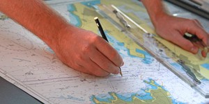
Do you ever wonder how pirates sailed the seven seas? The two most important things a pirate could have (besides a parrot and big hat) were a compass and an accurate watch. Ancient navigators didn't know about compasses, so how did they know where they were going? Could they have used the stars to know which way to go?Summary

Objective
In this experiment you can determine which stars to use to navigate in each hemisphere of the globe.Introduction
Does your new family car have a global positioning system, or GPS unit? This amazing device can tell you where you are going while traveling by car, airplane, boat or train. Most modern navigation is done using GPS, which uses information from satellites to tell you where you are and how to get to a particular destination. The information from a GPS is so accurate that it can be used to program an autopilot to conduct routine navigation. A GPS will tell you a location based upon latitude and longitude. The latitude tells you how far north or south you are, while longitude tells you how far east or west you are.
How did people navigate before modern technology?- Polynesians: By far, the most exceptional ancient navigation was by the Polynesians, who navigated thousands of miles throughout the Pacific Islands. They did not use any instrumentation to navigate. They used a type of celestial navigation called Wayfaring, which means that they used information about the stars, sun, moon, planets, ocean and tradewinds to know which way to go. They built boats with a system of rungs that would line up with key stars on the horizon for the navigator to tell direction. It took many years to train a navigator. The Hawaiian Star Compass was an incredibly accurate way to navigate. By developing this navigation system, the ancient Polynesians were way ahead of their time.
- Vikings: The Vikings primarily used coastal navigation, which means that they kept land in sight and knew to travel in one particular direction along the coast. Occasionally they would navigate long distances across the Atlantic Ocean in the summer. During these voyages they could not have used stars to navigate because at such northern latitudes the sun never sets during the summer months. Instead they used a sun compass, which could tell them direction by casting a curved shadow onto a disk with notches carved on it.
- Ancient Greeks: The ancient Greeks learned to voyage around Europe and the Mediterranean Sea. Two major advances in navigation were made by Ptolemy, a famous Greek astronomer. Ptolemy was the first to make maps using stories from travelers and sailors. He also was the first to use latitude and longitude to tell position on a map.
- Europeans: Eventually, Europeans learned to navigate using a magnetic compass and an accurate clock. How did they navigate before the discovery of the compass? They had the advantage of using Ptolemy's maps to show them where to go and primarily used coastal navigation. To orient themselves they used basic celestial navigation, which means that they used information from the stars and from the sun to orient themselves. The rising and setting of the sun could orient them East or West. The positions of navigational stars could orient them North and South.
Which stars are important for navigation? There are several, but the most famous navigational stars are the North Star, called Polaris, and the Southern Cross. The North Star (Polaris) is a part of the constellation Ursa Minor, commonly known as the Little Dipper. The Southern Cross is a constellation of four stars called Crixa, two of which point towards the celestial south pole.
Depending on where you are in the world and where you want to go, one navigational star will be more important than the other. In this experiment you can use the internet to find a star chart from anywhere in the world. You can look for the North Star and the Southern Cross from different locations around the world to see which star to use for navigation.
Terms and Concepts
To do this type of experiment you should know what the following terms mean. Have an adult help you search the Internet, or take you to your local library to find out more!- Navigation
- Latitude
- Longitude
- North Star (Polaris)
- Little Dipper (Ursa Minor)
- Southern Cross (Crixa)
- Northern Hemisphere
- Equator
- Southern Hemisphere
Questions
- Which stars are useful in the Northern Hemisphere?
- Which stars are useful in the Southern Hemisphere?
- How about along the equator?
Bibliography
Here are some helpful websites:- Pettersen, Franck, 1993. "The Viking Sun Compass: How the Vikings Found their Way Back from New York 1000 Years Ago." reproduced from the Planetarian, Vol. 22, #1, March, 1993. Retrieved August 7, 2006.
- Dolan, Graham. A History of Navigation. BBC, London, UK. Retrieved August 15, 2006.
- Kawaharada, Dennis. Wayfinding, or Non-Instrument Navigation. Polynesian Voyaging Society, Honolulu, HI. Retrieved January 20, 2006.
- Staff, 2005. Weather Underground. The Weather Underground, Inc. Ann Arbor, MI. Retrieved December 13, 2005.
Materials and Equipment
- Computer with internet access
- Star chart website or app
- Printer
- A globe or world map
Experimental Procedure
- First, you will need to pick out the cities you will use from around the world to navigate from. Get a globe or world map and look for interesting places. You should pick your hometown, a location along the equator, and at least two cities from each hemisphere.
- Search online for a free star chart website (or a star chart app on your tablet/phone). These are websites/apps that allow you to see what the stars will look like from a certain location on Earth (either a city or latitude/longitude) at a certain time of year. There are numerous free star charts available. If you find one confusing or difficult to use, try another one in your search results to see if it has an easier interface.
- Try looking up the star chart for your city on the current date.
- You should see a circular picture of constellations and stars, like the one below. You might notice some of the names of constellations because they are also the names of astrological signs like Pisces, Aries, Gemini or Leo.
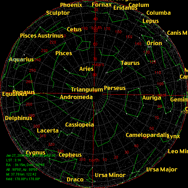
- Print out this page using a color printer and write the name of the city on the page. You can also save the picture to your computer by right-clicking on it and selecting save (for a PC) or by clicking and dragging the picture onto your desktop (for a Mac).
- Now repeat steps 2–5 for all of your other cities around the world. Be sure to write the name of the city on each page so you don't get them mixed up! Also make sure you keep the date constant for each city.
- Arrange all of your star charts on the table and look for either of the main navigational constellations, Ursa Minor or Crixa. On each page, circle these constellations with a marker.
- Now make a chart for your data. You should indicate the location and presence or lack of each navigational star in your table.
| City | Country | Hemisphere (N, S, Eq) |
North Star (Y/N) |
Southern Cross (Y/N) |
|---|---|---|---|---|
- What can you see by looking at your data? Is the North Star useful in all parts of the world? What about the Southern Cross? What is different about navigating near the equator?
Ask an Expert
Variations
- Which is more accurate, a star compass or a real compass? Print out a star chart for your city and take it to your back yard along with a compass at night. Compare the direction of the celestial North Pole or South Pole to the reading on your compass. Do the magnetic poles align with the celestial poles?
- You might notice that there are other stars in your star chart that are in the North or South direction. Why aren't these stars considered to be navigational stars? Try to change the date or time of your star chart. What happens to the location of those stars? Can you explain why some stars are good for navigation and others are not?
- You can find directions on how to make an ancient navigational tool like an astrolabe, sun compass, or cross staff. How do these instruments compare to a compass? Do some tools work better than others? Can you calculate the error for each tool?
Careers
If you like this project, you might enjoy exploring these related careers: