Summary
Edited by Ben Finio, PhD, Science Buddies
If you want a Project Idea with full instructions, please pick one without an asterisk (*) at the end of the title.
Abstract
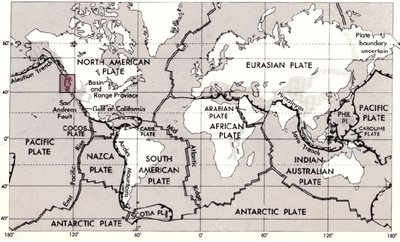
Today it is widely accepted that the Earth's crust consists of a series of huge plates that slowly move. The low parts of the plates are beneath the world's oceans, and the high parts of the plates are landmasses. New plate material is generated at deep sea ocean ridges in a process called sea-floor spreading. Material from plates is also recycled at trenches, where dense, oceanic crust dives back (subducts) underneath an adjacent plate towards the upper mantle. Figure 1 shows a map of the major tectonic plates.
The theory of plate tectonics revolutionized geology in the 1960s. Before this, geology had been a descriptive science. Mechanisms for large-scale processes such as the formation of mountain ranges were put down to vague "earth forces." Plate tectonics changed that. A series of scientific papers by Harry Hess, Robert Dietz, Fred Vine, Drummond Matthews, and others brought together a growing body of evidence that massive pieces of the earth's surface were constantly on the move. Subduction of one plate beneath another could provide the massive force to produce uplift of mountain ranges. Fifty years earlier, in 1912, Alfred Wegener had proposed his theory of continental drift, and was widely ridiculed. Wegener, like others before him, had noticed that the continents on either side of the Atlantic Ocean had complementary shapes, suggesting that they might have originated much earlier from the same landmass. He had also noted similarities in rock formations on opposite sides of the ocean, and similarities in both living and fossil animals. Wegener did not have a good explanation for how vast chunks of the earth's surface could move relative to one another, and the community of geologists was not ready to accept his ideas (McPhee, 1981-1998; WGBH, 1998).
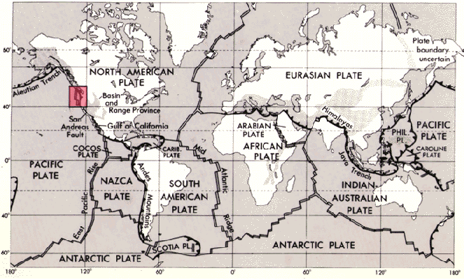 Image Credit: Robert I. Tilling / Public
A map of the world has a map of major tectonic plates overlaid on it. Each tectonic plate is labeled with the name of the plate and a red square outlines an area of the Pacific Northwest of America above the San Andreas fault line.
Figure 1. Map of major tectonic plates of the earth. (Tilling, date unknown).
Today we still do not know the mechanism for the motion of the plates, although it is thought that convection of heat from the earth's interior is somehow involved. The evidence that clinched the case for plate tectonics came from detailed mapping studies of paleomagnetism. Rocks containing magnetic material reveal the history of when and where they were formed. As the molten rock cooled, the magnetic particles aligned themselves with the earth's magnetic field. Although the positions of the earth's magnetic poles have changed over the billions years of earth's history, geologists have been able to recreate the time line of those changes. Armed with that information, geologists have been able to map the dates of origin of the oceanic crust, and to confirm that sea-floor spreading at suboceanic ridges and subduction at trenches is a constant process.
How are earthquakes related to tectonic plates? The following paragraph from Annals of the Former World by John McPhee, summarizes the connection quite well (McPhee, 1981-1998, 121):
Almost all earthquakes are movements of the boundaries of plates—shallow earthquakes at the trailing edges, where the plates are separating and new material is coming in, shallow earthquakes along the sides, where one plate is ruggedly sliding past another (the San Andreas Fault), and earthquakes of any depth down to four hundred miles below and beyond the trenches where the plates are consumed (Japan, 1923; Chile, 1960; Alaska, 1964; Mexico, 1985).
Use an online mapping tool or earthquake database, like the one available at https://earthquake.usgs.gov/earthquakes/search/, to look up information about earthquakes like their date, location, and magnitude. Here are some questions you could investigate for a science project:
- How do the locations of earthquakes relate to the boundaries of tectonic plates?
- Do any earthquakes occur that are not near a plate boundary? What causes them?
- Do the boundaries of some plates seem to be more active than others, like the "Ring of Fire" around the Pacific ocean?
- How frequent are earthquakes of different magnitudes?
- Have the magnitude or frequency of earthquakes changed over time for different locations?
- Can you identify any patterns that would make it possible to predict the approximate time or location of the next earthquake? Are any areas "overdue" for a major earthquake based on historic data?
Bibliography
For information on plate tectonics, see:
- WGBH, 1998. A Science Odyssey: You Try It: Plate Tectonics, WGBH, Boston, and PBSOnline. Retrieved on March 29, 2007.
- Kious, W.J. and R.I. Tilling, 1996. This Dynamic Earth: The Story of Plate Tectonics, U.S. Geological Survey. Retrieved on March 29, 2007.
- Tilling, R.I., 1998. Volcanoes, U.S. Geological Survey (online version of U.S. Government Printing Office publication). Retrieved on March 29, 2007.
This is a good, brief introduction to the structure of the Earth:
- Robertson, E.C., date unknown. The Interior of the Earth, United States Geological Survey, General Interest Report. Retrieved on January 30, 2007.
To find and map earthquake information (date, time, location, magnitude), see this webpage:
- USGS, 2007. Search Earthquake Catalog, United States Geological Survey, Department of the Interior. Retrieved on August 2, 2017.
Further reading: what could be more boring than reading about rocks? If you pick the right book, the geology of the Earth and the people who study it are downright fascinating. Here is an excellent and ambitious book on geology for the general reader by a masterful nonfiction writer, John McPhee (his set piece on plate tectonics runs from pages 115-131): McPhee, J., 1981-1998. Annals of the Former World. New York, NY: Farrar, Strauss and Giroux.
Ask an Expert
Global Connections
The United Nations Sustainable Development Goals (UNSDGs) are a blueprint to achieve a better and more sustainable future for all.

Careers
If you like this project, you might enjoy exploring these related careers: