Gigantic, Invisible Triangles: Measuring Height (or Altitude) with an Inclinometer
Abstract
If you've ever wondered how tall that bridge is, or how high your kite was, then this could be a good project for you. You'll learn how you can use the mathematics of right triangles to measure the height of an object with two measurements that you can make on the ground.Summary
Sources
- The do-it-yourself inclinometer (Quest Skyscope™) used in this project is from www.questaerospace.com.
/-/https/www.sciencebuddies.org/cdn/Files/2847/3/Math_img062.jpg)
Objective
The goal of this project is to measure the heights of tall buildings (or the altitude of a kite, or a model rocket at the top of its flight), using a device for measuring angles and some basic properties of right triangles.Introduction
Imagine you're visiting Paris, and you want to know the height of the Eiffel Tower. You didn't bring your computer on this trip, so you can't just look it up with a web search. Besides, you're the kind of person who likes to figure things out on your own. With just two measurements that you can make while standing on the ground, you can figure out how tall the tower is. Figure 1 shows how it works.
/-/https/www.sciencebuddies.org/cdn/Files/2847/3/Math_img062.jpg)
Figure 1. How to measure the height of the Eiffel Tower.
This measurement is based on the mathematics of right triangles. You will need to pace off a good distance from the object you want to measure. (Just how far is 'a good distance'? Well, that can be one of the things you investigate with this project!) The distance you walk away from the object is the first of the two measurements you need to make. For our example, let's assume that you walked 575 meters from the base of the tower.
This distance is also the baseline of the right triangle in Figure 1. The height of the object is the other leg of the right triangle. Your line of sight to the top of the object forms the third side of the right triangle (called the 'hypotenuse'). The second measurement that you need to make is the angle between your line of sight and the ground (the baseline of the right triangle). In Figure 1, the angle is marked with the double-headed arrow and the Greek letter θ (pronounced thay'-ta). Mathematicians are fond of Greek letters in equations, and θ is the one they often like to use for angles. The Experimental Procedure section will show you how to make a simple device, called an inclinometer to measure the sight angle. For our example, let's assume that the angle you measured was 29°.
OK, so you have your measurement of the baseline length (575 m), and your measurement of the sight angle (29°). How does this help you figure out the height? This is where the mathematics of right triangles comes in. By definition, a right triangle has one ninety-degree angle, and two other angles, each less than ninety degrees (the sum of the three angles of a triangle is always 180 degrees). Figure 2 shows our right triangle without the Eiffel Tower in the way. The right angle is marked by the small square, our sight angle is θ, and the remaining angle has to be 90−θ (so that all of the angles add up to 180).
/-/https/www.sciencebuddies.org/cdn/Files/2848/3/Math_img063.jpg)
Figure 2. Right triangles and the tangent (tan) function.
It turns out that the angle θ has a special mathematical relationship with sides a and b. For a given angle, the ratio of the length of those two sides is always the same. a/b is equal to the tangent of the angle θ. In equation form, it looks like this:
Another way to write this same equation is:
This means that the height we want to measure (a) is equal to the baseline of the right triangle (b) times the tangent of the sight angle (θ). So the height should be:
Here is a graph of the tangent function for angles ranging from 0 to 89 degrees (Figure 3). You can see that the values change slowly and steadily from 0 until somewhere between 60 and 70 degrees, when the values start to change more rapidly. Between 80 and 89 degrees, the values increase very rapidly indeed. You'll want to make sure that you are far enough away from the object so that your sight angle is in the range where the tangent function is not changing rapidly.
/-/https/www.sciencebuddies.org/cdn/Files/2849/3/Math_img064.jpg)
The graph plots every value of a tangent function from 0 to 89 degrees. The values slowly increase as the angle approaches 89 and drastically increases from when the angles reach about 84 degrees.
Figure 3. Graph of the tangent function from 0 to 89 degrees.
What happens to the tangent function when the angle reaches 90 degrees? It blows up! Think for a second what a sight angle of ninety degrees would mean: you'd be looking straight overhead. Since you'd walked 'a good distance' away from the object, this wouldn't make sense. It's like trying to draw a triangle with two ninety-degree angles—it's not possible!
When you get back from your Paris trip, you Google the Eiffel Tower and find out that the actual height is given as 324 m. So how accurate was your measurement? Well, the difference between the actual height and your measurement is 324 − 319 = 5 meters. As a percentage of the actual height, that's 5 / 324 * 100 = 1.5%. Not bad at all! You'll be doing really well if you can get within 2%. (Try seeing how much difference it would make if your angle measurement was off by 1 degree.)
Note: in Figure 1, you will notice that the triangle goes right down to the ground. So does that mean that you have to lie down to get the correct angle? Thankfully, the answer is 'no.' As long as your baseline is a reasonable distance, the error introduced by your height is insignificant. In fact, if you examine Figure 1 closely, you'll see a small speck right where the observer would be. That speck is actually a stick figure! (See the magnified view in Figure 4) The triangle is drawn to the proper scale for a baseline distance of 575 meters. To make the stick figure 'visible,' it had to be drawn at twice the size of a tall person. That speck is a scale 4 meters tall!
/-/https/www.sciencebuddies.org/cdn/Files/2850/5/Math_img066.jpg)
Figure 4. Greatly magnified (approximately 33x) view of Figure 1, showing the observer's position The stick figure is a scale 4 m tall in order to remain visible in the original illustration (Figure 1).
Now it's time to do your background research, make an inclinometer, and get started on your own measurements! By the way, good luck with convincing your parents to take you to Paris to do your Science Fair project!
Terms and Concepts
To do this project, you should do research that enables you to understand the following terms and concepts:- Right triangle
- Hypotenuse
- Opposite side
- Adjacent side
- Tangent
- Ratio
Questions
- For what range of angles does the tangent function change rapidly?
- For what range of angles does the tangent function change more slowly?
- Which range of angles do you think would work better for making accurate height measurements?
- What implications does this have for choosing the right length for your baseline when you are making your sightings?
Bibliography
- The inclinometer used in this project is from Quest Aerospace. There's also an alternative (but similar) design from the Exploratorium:
- Quest Aerospace, 2007. Quest's DIY Inclinometer: The Skyscope, Quest Aerospace. Retrieved March 2, 2007.
- Exploratorium, date unknown. Height Site: Making Your Inclinometer, Exploratorium. Retrieved March 2, 2007.
- Google, 2007. "Google Earth," Google. Retrieved March 2, 2007.
Materials and Equipment
To do this experiment you will need the following materials and equipment:- Computer with Internet access and printer
- One letter-size sheet of card stock
- Popsicle stick
- Paper clip
- Brad (for attaching papers together)
- Large paper clip
- Scissors
- Stapler
- Hole punch
- White glue
- Long tape measure (for measuring length of baseline); alternatives:
- Pre-measured length of rope
- Calibrated pedometer
- A helper
- Tall buildings to measure
For measuring baseline distances in urban areas, you may be able to use the Google Earth program. You'll need a fairly recent computer, and you'll have to be good at figuring out locations on the ground from satellite photos and maps.
Experimental Procedure
- Make your inclinometer.
- Download the inclinometer template file (requires Adobe Acrobat Reader), and follow the instructions it contains to make your own inclinometer (Quest Aerospace, 2007).
- There is an alternative method for making your own inclinometer. See the Exploratorium reference in the Bibliography (Exploratorium, date unknown).
- Choose the objects whose heights you want to measure (e.g., buildings, kites, rockets).
- Find a good location from which to make your sightings.
- The sighting location should be level with the base of the object whose height you are measuring.
- Obviously, you need an unobstructed view to the top of the object whose height you are measuring.
- You need an accurate measure of the distance from your sighting location to the base of the object (the baseline length). Use your tape measure or measuring rope (be sure not to stretch it).
- Alternatively, you can 'pace off' the distance, counting each step. You have to be careful to walk with a steady stride, and you'll also need to know the length of your stride (your average step size). To measure your average step size, walk the length of a football field several times, counting the number of steps each time. Divide the length of the field by your average number of steps to get your average step size. If you have a pedometer, it will count your steps for you.
- From your sighting location, use your inclinometer to measure the angle to the top of the object.
- Hold the inclinometer up and sight along its top edge to line it up with the highest point of the object you are measuring.
- The 'bob' will hang down, marking the angle of inclination. While still holding your sighting, have your helper read the angle from the inclinometer. (Alternatively, pinch the bob against the inclinometer to hold the reading, and read it yourself. This will take practice to get it right, and you'll need a helper to confirm that you got the correct angle while you practice.)
- For each object that you measure, take at least 3 sightings.
- Calculate the average of your angle measurements.
- Keep track of your measurements in a data table in your lab notebook. It might look something like this:
Object
baseline
(m)θ1
(deg)θ2
(deg)θ3
(deg)θavg
(deg)tan θavg
height
(m)Eiffel Tower 575 29 28 31 29 0.5543 319 etc. - Calculate the height of the object by multiplying the baseline length by the tangent of the angle you measured. To find the tangent of an angle, you can use the table. (If you use a calculator instead, make sure that it is expecting your angles to be in degrees.)
θ
(deg)tan θ
θ
(deg)tan θ
θ
(deg)tan θ
θ
(deg)tan θ
θ
(deg)tan θ
θ
(deg)tan θ
0 0.0000 15 0.2679 30 0.5774 45 1.0000 60 1.7321 75 3.7321 1 0.0175 16 0.2867 31 0.6009 46 1.0355 61 1.8040 76 4.0108 2 0.0349 17 0.3057 32 0.6249 47 1.0724 62 1.8807 77 4.3315 3 0.0524 18 0.3249 33 0.6494 48 1.1106 63 1.9626 78 4.7046 4 0.0699 19 0.3443 34 0.6745 49 1.1504 64 2.0503 79 5.1446 5 0.0875 20 0.3640 35 0.7002 50 1.1918 65 2.1445 80 5.6713 6 0.1051 21 0.3839 36 0.7265 51 1.2349 66 2.2460 81 6.3138 7 0.1228 22 0.4040 37 0.7536 52 1.2799 67 2.3559 82 7.1154 8 0.1405 23 0.4245 38 0.7813 53 1.3270 68 2.4751 83 8.1443 9 0.1584 24 0.4452 39 0.8098 54 1.3764 69 2.6051 84 9.5144 10 0.1763 25 0.4663 40 0.8391 55 1.4281 70 2.7475 85 11.4301 11 0.1944 26 0.4877 41 0.8693 56 1.4826 71 2.9042 86 14.3007 12 0.2126 27 0.5095 42 0.9004 57 1.5399 72 3.0777 87 19.0811 13 0.2309 28 0.5317 43 0.9325 58 1.6003 73 3.2709 88 28.6363 14 0.2493 29 0.5543 44 0.9657 59 1.6643 74 3.4874 89 57.2900 - How reproducible are your measurements?
- What height would you calculate if you used the biggest angle you measured?
- What height would you calculate if you used the smallest angle you measured?
- More advanced students should calculate the standard deviation of the angle measurements. See the Science Buddies How-To page Variance & Standard Deviation.
- What height would you calculate if the measured angle was your average plus one standard deviation?
- What height would you calculate if the measured angle was your average minus one standard deviation?
- You might also want to investigate the accuracy of your baseline measurements, using a similar technique as for the angle.
- How accurate are your measurements?
- If the height of the building you measured is known, what is the difference between your measurement and the actual height?
- To calculate the percentage error, divide the difference by the actual height of the building and multiply by 100.
Ask an Expert
Global Goals
The United Nations Sustainable Development Goals (UNSDGs) are a blueprint to achieve a better and more sustainable future for all.
/-/https/www.sciencebuddies.org/cdn/Files/19752/5/E-WEB-Goal-09.png)
Variations
- Examine the graph of the tangent function in the Introduction. For what range of angles does the tangent function change rapidly? For what range of angles does the tangent function change more slowly? Which range of angles do you think would work better for making accurate height measurements? Try measuring the height of the same building from several different locations to test your hypothesis (in other words, use several different baselines for your imaginary right triangle).
- For measuring baseline distances in urban areas, you may be able to use the map and satellite image data available in the Google Earth program (Google, 2007). For example, we were easily able to identify the Eiffel Tower, and to measure a distance to a plausible observation point in a nearby park (yellow line in Figure 5, 575 m). It would be a good idea to check a known distance on a local Google Earth map before relying on this method.
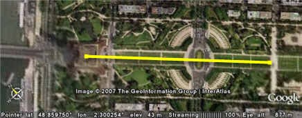
Figure 5. Measuring urban distances using Google Earth (Copyright 2007, The GeoInformation Group Interatlas via Google Earth) - Another alternative for measuring baseline distances would be to use the Google Maps pedometer. It would be a good idea to check a known distance on a local Google map before relying on this method.
/-/https/www.sciencebuddies.org/cdn/Files/2852/3/Math_img065.jpg)
Careers
If you like this project, you might enjoy exploring these related careers:
/-/https/careerdiscovery.sciencebuddies.org/cdn/Files/896/17/pexels-photo-3761508.jpg)
/-/https/careerdiscovery.sciencebuddies.org/cdn/Files/1133/17/pexels-photo-3862135.jpg)
/-/https/careerdiscovery.sciencebuddies.org/cdn/Files/1125/17/pexels-photo-3862390.jpg)
/-/https/careerdiscovery.sciencebuddies.org/cdn/Files/1822/17/Tide_station_leveling.jpg)

/-/https/img.youtube.com/vi/2awrEVrPpdI/0.jpg)
/-/https/img.youtube.com/vi/q9X-ez31oiY/0.jpg)
/-/https/img.youtube.com/vi/CPOKDru-2ug/0.jpg)