Animal Magnetism: Do Large Mammals Align Themselves with Earth's Magnetic Field?
Abstract
We rely heavily on our senses to tell us about our environment. But in addition to the senses of touch, smell, taste, hearing, and sight, some animals are able to sense Earth's magnetic field. Migratory turtles and birds use this sense to guide them on long journeys. Homing pigeons use it to find their way home. New research suggests that large mammals, such as cows and deer, may also have the ability to sense the direction of magnetic north. In this animal behavior science project, you will put this theory to the test and use Google EarthTM to find herds of grazing animals, then analyze their orientation to see if they are aligned with the local magnetic field.Summary
This experimental procedure is based on notes from Dr. Sabine Begall, who generously provided latitude and longitude coordinates, and contributed information for the procedure.
David B. Whyte, PhD, Science Buddies
This science fair project was inspired by the following California State Science Fair project:
Watkins, Christa G. (2009). Equine Magnetic Orientation.
- Google EarthTM is a registered trademark of Google Inc.
- Microsoft® and PowerPoint® are registered trademarks of Microsoft Corporation.
/-/https/www.sciencebuddies.org/cdn/Files/3928/10/magnetic-declination-map.jpg)
Objective
Identify grazing animals using Google Earth and determine if they have aligned themselves with Earth's magnetic field.
Introduction
Our senses provide us with information about our environment. They help us find food and shelter, and to avoid danger. Human senses include sight, sound, taste, smell, and touch. But other animals have developed different kinds of senses that are not (as far as we know) used by humans. These other senses include echolocation, infrared vision, electric sense, and magnetic sense. Echolocation is used by bats and whales to determine the location and speed of things in their environment. Infrared vision is used by certain kinds of snakes to identify warm-blooded prey in low-light conditions. Certain kinds of fish are able to create an electric field (the electric sense), which can be used to detect environmental cues in murky water. And finally, magnetoreception is the ability to detect a magnetic field to perceive direction, altitude, or location. This sense is used by a surprising number of animals, including honeybees, sharks, sea turtles, rays, homing pigeons, migratory birds, tuna, and salmon. The question of whether large mammals are capable of magnetoreception has been controversial.
Recently, research has suggested that large mammals, such as deer and cows, do, in fact, have the ability to sense Earth's magnetic field. Dr. Sabine Begall, and colleagues in Germany and the Czech Republic, published a paper in the Proceedings of the National Academy of Sciences (PNAS), entitled "Magnetic alignment in grazing and resting cattle and deer" (see the Bibliography for details). It is important to be clear that the orientation of grazing animals that was investigated was not due to other factors. For example, cattle stand perpendicular to the sun on cold, sunny days, especially in the early morning, maximizing the surface area exposed to sunlight and gaining heat. On the other hand, cattle orient parallel with strong winds during winter, which minimizes the area exposed to heat loss associated with wind. But the paper claims that when other factors are not present, cattle and deer align themselves with Earth's magnetic field. It is not clear why they align themselves in this way or how they can sense magnetism. It would be a good idea to read Dr. Begall's paper prior to starting this science fair project. There are lots of details in the paper that will be useful if you choose this project.
In this zoology science project, you will investigate the alignment of cattle, sheep, horses, or other large mammals. You will use Google Earth to find grazing herds. The direction in which the animals are facing will be recorded. It is often not possible to tell which side of the animal is the head and which side is the rear, so you will just determine the direction of the long axis of their bodies.
The maps in Google Earth have geographic north at the top. Geographic north is not the same as magnetic north. Geographic north is the direction you would travel to get to the northern axis of Earth's rotation. Magnetic north is the direction toward the north magnetic pole in the local area. The difference between magnetic north and geographic earth is called the declination. If the area under study has a declination of 10 degrees east, the direction that a compass needle points is "off" by 10 degrees from true geographic north. The direction of true north in this case is 10 degrees west of north, as indicated by the compass needle. The declination for any locale on Earth can be found online. You will use the declination to adjust the orientations found in grazing animals. Note that the procedure uses a slightly different way of recording the angles of the animals than the one found in Begall's paper. In the paper, the angles of the axes are recorded relative to geographic north and then corrected for declination. In the procedure for this science project, the angles of the axes are taken relative to the local magnetic north. This will make the bookkeeping easier.
This is an advanced research-based science fair project that will take a lot of time and effort. You will have to use a lot of creative problem solving and self-guided research to complete the project. A set of coordinates for some of the herds of animals that were used in the paper by Dr. Begall are provided to get you started. If you choose to find and analyze your own herds of animals, you will be providing new data in this exciting area of research!
Terms and Concepts
- Senses
- Echolocation
- Infrared vision
- Electric sense
- Magnetoreception
- Magnetic alignment
- Google Earth
- Geographic north
- Magnetic north
- Declination
Questions
- What are some examples of how animals use magnetoreception?
- What are some examples of other senses that appear to be absent in humans, but that are present in other living things?
- Based on your research, what experiments have been done to show that homing pigeons can sense Earth's magnetic field?
- What units are used to describe the strength of Earth's magnetic field?
Bibliography
- Begall, Sabine, et al. "Magnetic alignment in grazing and resting cattle and deer." Proceedings of the National Academy of Sciences (PNAS), Vol. 105, No. 36, September 9, 2008: 13451–13455. Retrieved August 1, 2009.
- United States Geological Survey (USGS). (2014, January 2). Introduction to Geomag. Retrieved June 5, 2014.
- National Geophysical Data Center. (n.d.). Geomagnetism. Retrieved August 2, 2009.
- National Geophysical Data Center. (n.d.). Magnetic Field Calculators: Estimated Value of Magnetic Declination. Retrieved June 5, 2014.
- AbsoluteAstronomy. (2009). Magnetoreception. Retrieved August 1, 2009.
Materials and Equipment
- Computer with both PowerPoint®, or a similar program, and Google Earth installed
- Protractor
- Ruler
- Lab notebook
Experimental Procedure
Selecting a Pasture in Google Earth
- Install and start Google Earth on your computer.
- Look for suitable grazing animals.
- Compromise between resolution and visibility of the cattle.
- View initially from approximately 200–600 meters (m), and later, at 80–200 m.
- Here is a selection of locations that have herd animals. Copy and paste these coordinates into the "Fly to" box in Google Earth to see the grazing animals. Because Google Earth updates its pictures, for some locations you will need to look at an older picture to find the grazing animals, as described below in step 3.b.i. Note the way the latitude and longitude are written. The angle is given in degrees, minutes and seconds, with a space in between each number. Seconds are given to two decimal places. Latitude is north (N) or south (S) and longitude is east (E) or west (W).
- Argentina: 29 26 25.31 S, 61 44 44.19 W
- Denmark 56 08 07.69 N, 8 41 54.03 E
- Use the picture taken on 7/30/2005 for this location. Note: You can change the date of the picture by clicking on the year shown in the box in the bottom left corner of the screen. This will make a horizontal scroll bar appear in the top left corner of the screen. Use this scroll bar to change the date of the picture shown.
- France 1: 45 46 40.30 N, 1 11 41.18 E
- Use the picture taken on 9/4/2006 for this location.
- France 2: 45 54 40.92 N, 1 13 42.09 E
- Use the picture taken on 9/4/2006 for this location.
- France 3: 45 49 56.72 N, 1 21 41.95 E
- Use the picture taken on 9/4/2006 for this location.
- Germany 1: 51 21 27.51 N, 6 57 50.84 E
- Germany 2: 51 23 09.83 N, 7 03 13.65 E
- Netherlands: 51 46 43.65 N, 05 27 01.23 E
- US-New York 41 56 35.47 N, 73 39 02.65 W
- Use the picture taken on 4/29/2004 for this location.
- US-Texas: 30 12 07.07 N, 96 10 35.62 W
- Use the picture taken on 1/14/2006 for this location.
- US-Texas 30 13 33.94 N, 95 59 21.80 W
- Use the picture taken on 1/14/2006 for this location.
- Note: Do not forget to zoom in on the coordinates above. Initially zoom in to view from approximately 200–600 m, and later, zoom to 80–200 m. Look closely for the grazing animals.
- Tip: If the images were taken after 2006, there may not be grazing animals at the location given, but if you look at an older picture of that location, or search around within that pasture (or nearby pastures), then you will likely find grazing animals.
- Carefully choose at least 10 pastures to analyze. They should not be:
- Too close to large water or power lines,
- On mountain slopes, or
- In the immediate vicinity of human settlements.
- Make sure the map has geographic north on the top (click on "N").
- Take a screenshot of the grazing cattle.
- Look at your computer manual for how to take a screenshot.
- Make sure you are in full-screen mode.
- If a pasture has to be broken up into several PowerPoint slides, label the slides appropriately.
- Paste the screenshot into PowerPoint, or a similar program.
- Note the latitude and longitude in the lower left corner.
Finding Magnetic North
- Go to the Magnetic Declination Calculator at http://www.ngdc.noaa.gov/geomag-web/.
- Enter latitude, longitude, and date. For the model, use IGRF 11.
- Click on "Calculate."
- Record the declination output in your lab notebook.
- For example, the output for the Denmark location on July 30, 2005, is "0° 28' E changing by 8.4' E per year." See Figure 1, below, for a picture of this.
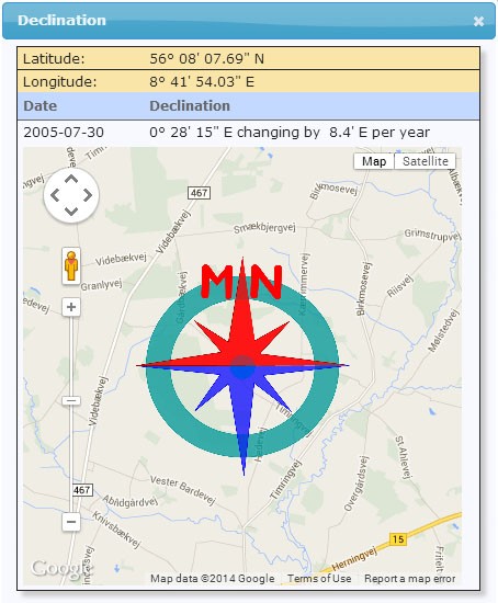
GPS coordinates of a location in Denmark are shown on a map with a compass overlay. The compass is color coded with red showing the direction of magnetic north.
Figure 1. Output of the declination calculator for the Denmark location. Declination = 0° 28' E changing by 8.4' E per year. The compass shows the approximate bearing of the magnetic north, where the red arrow points toward magnetic north.
- Note that the declination changes with time. In the example, it is changing by 8.4' per year in an easterly direction. For the purposes of this science fair project, you should ignore the fact that the declination is changing with time. You can average over several years to compensate for this change, if you choose.
- For example, the output for the Denmark location on July 30, 2005, is "0° 28' E changing by 8.4' E per year." See Figure 1, below, for a picture of this.
- Draw a line that shows magnetic north on the PowerPoint image of the pasture.
- The next step will be to determine the angle between magnetic north, which you just drew on the image, and the axis of each animal in the image.
/-/https/www.sciencebuddies.org/cdn/Files/3928/10/magnetic-declination-map.jpg)
Evaluating Body Direction
- Draw a straight line through the long axis of each cow's body.
- Cows in water or on trails should not be evaluated.
- Calves should not be evaluated.
- Number each axis that you use on the PowerPoint image.
- Use the protractor to determine the angle of the cow's body relative to magnetic north.
- Since you are not recording which way the animal is facing (since you may not be able to distinguish head from tail), do not use a full circle of 360 degrees.
- Use -90 degrees for west, 0 degrees for north, and +90 degrees for east.
- A value of +7, for example, would represent an axis slightly to the right of magnetic north.
- In your lab notebook, record the angular values you found for each pasture (also record the latitude, longitude, and country) in a data table (one column per pasture).
Analyzing Your Data
- Graph the angular values on a half circle, with one point for every animal. See an example in Figure 2, below.
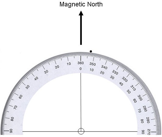
Figure 2. Example of a magnetic orientation graph. Data point for one animal at +7 degrees off of magnetic north is shown.
- Is there a clear trend for the animals to align themselves with the magnetic field of Earth?
- What percentage of the animals is aligned between -45 degrees and +45 degrees?
/-/https/www.sciencebuddies.org/cdn/Files/3929/5/Zoo_img050.jpg)
Ask an Expert
Global Goals
The United Nations Sustainable Development Goals (UNSDGs) are a blueprint to achieve a better and more sustainable future for all.
/-/https/www.sciencebuddies.org/cdn/Files/19758/6/E-WEB-Goal-15.png)
Variations
- In order to determine how strongly the data supports the theory that the animals are aligned in a north-south axis, you will have to perform some statistical analysis of the data. See the paper by Begall, S. et al. in the Bibliography for how to go about this.
- If grazing animals do align themselves with the magnetic field of Earth, are there certain geographic features that can disrupt this alignment, such as the presence of high-voltage power lines in the area? Do this science project again but this time look for grazing animals near high-voltage power lines and compare their alignment to the grazing animals you analyzed in this science project (which should not have been near high-voltage power lines). Does the presence of high-voltage power lines affect how grazing animals align?
Careers
If you like this project, you might enjoy exploring these related careers:
/-/https/careerdiscovery.sciencebuddies.org/cdn/Files/1900/17/iStock-1191167137.jpg)
/-/https/careerdiscovery.sciencebuddies.org/cdn/Files/1713/17/pexels-photo-3769021.jpg)
/-/https/careerdiscovery.sciencebuddies.org/cdn/Files/1402/17/unsplash-anvQH3z5vBY.jpg)
/-/https/careerdiscovery.sciencebuddies.org/cdn/Files/1353/18/iStock-579224842.jpg)

/-/https/img.youtube.com/vi/uIV031bnmFA/0.jpg)
/-/https/img.youtube.com/vi/KlvfgG6m70w/0.jpg)
/-/https/img.youtube.com/vi/cHsBr9v2YBw/0.jpg)